Angus Sanguez is 67-years-old and whippet-thin. His face has been weathered by years of living in the Dehcho region in Canada’s Northwest Territories, a sub-Arctic wilderness that is on the frontlines of climate change.
Sanguez was born and raised in the Dene community in Tthets’ek’ehdeli (also known as Jean Marie River), one of six indigenous communities in the Dehcho region. Covering 215,615 sq km, the Dehcho is twice the size of England, inhabited by only 3,000 people, as well as countless moose, bears and bison that roam over a massive storehouse of carbon trapped in permafrost.
Sanguez was visiting the Scotty Creek Research station in Canada’s sub-Arctic when he had a eureka moment gazing upon dying trees that could no longer root themselves in the thawing peat. “So that’s why they call this a ‘drunken forest,’” he said. “I heard that term many times. But I never knew what it meant. Now I see these how these trees that have fallen down everywhere are likes drunks coming out of a bar, falling down and leaning up against each other. We are seeing a lot of this.”
Climate change is the latest threat to the lives and livelihoods of the Dene people. For decades, they have successfully fended off Big Oil and largely resisted invitations to partner with fossil fuel companies. Instead, they are collaborating with scientists and the national government to create and monitor Canada’s first indigenous protected area, in what they hope can be a model for others.
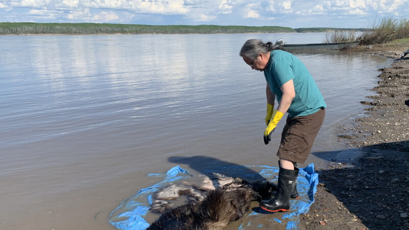
Dene national chief Gerry Antoine washes off a moose hide in preparation for tanning. Credit: Edward Struzik
Climate change is transforming the Dehcho. It is one of the most rapidly warming regions on Earth.
In recent years, Sanquez and the Dene have experienced catastrophic flooding, massive landslides that have drained and browned lakes, and runaway wildfires like the ones in 2014 that burned 570,000 hectares of forest in the southern territories. Those 380 fires released roughly 94.5 megatonnes of carbon, half of the carbon sequestered annually in all of Canada, as well as a potentially toxic form of mercury that has been locked in permafrost.
William Quinton, a Laurier University scientist who has been monitoring the impact of climate change on permafrost in the Dehcho for 23 years, runs the Scotty Creek Research Station 50 km south of Fort Simpson, a remote village, 500km west of the capital Yellowknife.
Permafrost is like a cement that holds carbon rich peat, rocks and mineral-richly soils together. In addition to warmer temperatures, drilling for oil, and mining for metals and minerals can hasten its thaw and complicate the maintenance and cleanup of mines such as the abandoned Cantung mine located along one of the headwaters of the Nahanni River system.
The thawing permafrost can also be seen in the seismic lines around Scotty Creek that were bulldozed to identify sources of oil and gas. The lines, the single largest human disturbance in the Dehcho region, were streaming with water that had percolated up from the thawing permafrost.
In the 1950s, permafrost covered nearly 75% of the 152 square km drainage area of Scotty Creek. It’s down to a third of that. Where there still is permafrost, it is often covered by a layer of talik, unfrozen ground that does not refreeze in winter when snow acts like a blanket, trapping some of the heat.
Thick, long lasting snow cover followed by a quick spring meltdown helps spread the thaw downwards and outwards. Trees literally drown as the ground surface collapses into depressions, and as melting snow and rain fills those depressions with water. Quinton has had to move his research camp twice to avoid being flooded out.
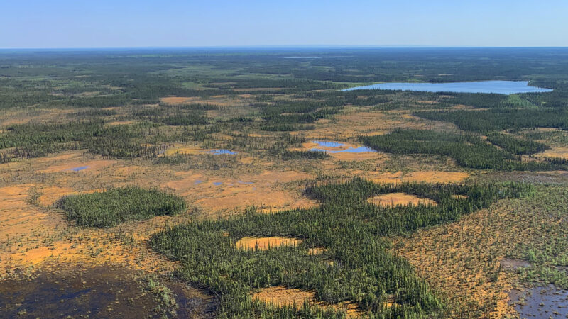
Bogs and wetlands dominate much of the landscape in the DehCho region. Credit: Edward Struzik
“What we’re seeing perhaps more clearly than any other place in the world is ecosystem change occurring in fast motion,” said Quinton. “The involvement of the Dene is important to our understanding of what is happening because the elders here have a longer record of what was there in the past and how it is affecting fish and wildlife.”
From Fort Simpson, a small single-engine float plane flew us across a wilderness that spread out as far as the eye could see towards the Mackenzie Mountains where the last icefields in the mainland of the Northwest Territories are wasting away as fast as sea ice is melting.
The lessons learned at Scotty Creek have been sobering, said Quinton at Goose Lake. It was so hot and buggy that on shore, the typically gregarious ravens (datsą́) and trickers whisky jacks, (ohk’aa), were lying low. The Mackenzie Valley can be the hottest place in Canada in summer and the coldest in winter.
“It’s tough to be a tree in this landscape,” Quinton said. “The thawing that we are seeing is turning forests into bogs and other wetlands that may not be able to support the fish and animals that the Dene rely on for food and clothing.”
“The implications for water quality, vegetation changes, biodiversity and for the people living in this part of the world are profound,” he said.
The best way of visualising what Quinton is talking about is to describe what occurred 300km to the northeast in the Mackenzie bison sanctuary. Warming temperatures and the 2014 wildfires thawed permafrost so intensely that incoming water from groundwater channels drove most of the 700 wood bison out of the protected area.
The exodus was so complete, according to Terry Armstrong, a biologist working for the government of the Northwest Territories, that he had a difficult time finding animals when he flew in to do a count the following year.
No one can say with certainty whether it was swamping that drove the animals out. But York University scientist Jennifer Korosi who was there at Scotty Creek says it’s hard not to make the connection considering the amount of water in the sanctuary doubled between 1986 and 2014 and Falaise Lake, the largest in the sanctuary, grew by 824%.
The tree ring and sediment coring Korosi did indicates that flooding has occurred in the past, but not nearly on this scale, for the past 300 years. Indigenous elders say nothing like it has happened in their lifetime.
#mc_embed_signup{background:#fff; clear:left; font:14px Helvetica,Arial,sans-serif; }
/* Add your own Mailchimp form style overrides in your site stylesheet or in this style block.
We recommend moving this block and the preceding CSS link to the HEAD of your HTML file. */
The message from indigenous elders and leaders at Fort Simpson was unambiguous. “Climate change is not going to wait for us to find a way of adapting and mitigating,” said Gladys Norwegian, former chief of Jean Marie River and grand chief of the Dehcho.
“It’s happening now. We need to work as partners with scientists at Scotty Creek to see what is coming. We also need to get our own act together,” Norwegian said.
What the Dene community would like to know from the Canadian scientists they are collaborating with is how future warming will further impact their food, water and infrastructure, which is built on rapidly thawing permafrost. They are working with scientists at Scotty Creek as equal partners, to learn and better evaluate resource developments and climate impacts on their land.
Quinton believes the “unique fusion of science and indigenous knowledge” provides a model for other indigenous communities in Canada facing climate threats.
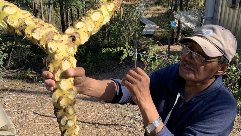
Angus Sanguez shows the roots of a pond lily. The Dene community use this lily and other bog plants such as black spruce sap as pharmaceuticals. Credit: Edward Struzik
“It is a clear departure from how science and land management was conducted in the north in the past,” he said. “Because the livelihoods of the people here are so closely dependent on what is happening on the land, a management approach that puts them in leadership positions is critical.”
Not only does thawing lead to erosion and flooding, it dissolves carbon in water and enhances microbial activity that can transform harmless elemental mercury securely stored in permafrost into toxic methylmercury. This brownification of streams, rivers and lakes is how University of Waterloo scientist Heidi Swanson and University of Alberta ecologist Dave Olefeldt got involved.
With Sanguez’s assistance, Swanson is testing fish for mercury and at their request, advising people what fish they can eat. Olefeldt and his team are tracking the movement of mercury through these catchments.
There is no discernible sign yet that the contaminated fish are affecting human health. But George Low, who coordinates the aquatic resources and oceans management programme for the Dehcho First Nations, says it’s important to keep track of what’s going on, given how many fish are consumed by indigenous people.
Community members like Sanguez are assisting Swanson in an experiment to remove some of the older, bigger fish from lakes. This leaves the younger fish with more food and the opportunity to grow fast without accumulating so much mercury.
The merging of science and indigenous knowledge has been a long time in the making largely because of prejudices stemming from the colonialist era. George Simpson, Scottish-born governor of the Hudson Bay Company as it aggressively expanded fur trading in the 1800s, revealed typically racist views in his private letters, describing Dene women he bedded as “bits of brown”.
A more constructive meeting of minds began to gel in the mid 1970s when a consortium of energy companies proposed building a 3,860 km long natural gas pipeline through the Mackenzie Valley. No one in the indigenous communities knew how a pipeline as big as that might affect caribou migration, or whether it could stand up to thaw. Neither did the energy companies. In spite of many other knowledge gaps, the Canadian government enthusiastically supported the project until public hearings overseen by Justice Thomas Berger came to a fiery head in Fort Simpson in December 1975.
Speaking for all the Dene people, Jim Antoine, a young leader from Fort Simpson, told Berger that he was willing to lay down his life to stop the $10 billion project.
Antoine’s speech made news all across Canada. Few people believed that it would end as badly as it did in Mexico when the Chontales Indians were violently cleared out as they tried to block access roads to oil and gas installations in 1976. But threats to blow up a pipeline in northern Canada rattled government and resources industry officials who were used to getting their way with indigenous people.
In the end, Berger was sympathetic. In a landmark report that got a reluctant nod from the Canadian government, the judge recommended a ten year moratorium on development in the region until land claims were resolved and wilderness protected for the benefit of the Dene.
Antoine went on to become premier of the Northwest Territories. At the request of the Dene, Nahanni National Park – a United Nations World Heritage site – was expanded to protect the headwaters of many of the rivers that drain into the Mackenzie watershed.
Data exclusive: The ‘junk’ carbon offsets revived by the Glasgow Pact
The biggest development occurred this year when the Dehcho First Nations and the Canadian government finalised a deal to set aside 14,218 square km of land in the Horn Plateau, Hay River Lowlands and Great Slave Plain as a national wildlife area. Edéhzhíe became the first indigenous protected area in Canada in 2018 and the government provided a C$10 million grant ($8m) to the Edéhzhíe Trust Fund to support the Dehcho K’éhodi Stewardship and Guardians Program.
The indigenous guardians work with scientists to monitor climate and environmental changes in the region. They also share scientists’ insights with community members.
William Alger, one of the guardians, is positive about the programme. “I learn from elders where the fish and animals are and the changes they see that are taking place,” he said.
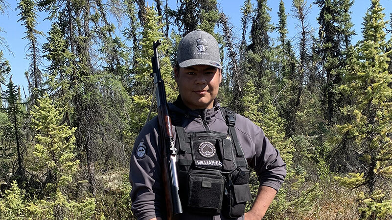
Indigenous guardians like William Alger monitor environmental changes in the landscape and share scientists’ insights with community members. Credit: Edward Struzik
Quinton sees the guardian programme as a way of “ground truthing” the science that he and his colleagues are doing. Once the Dene learn how do the science at Scotty Creek, they will be able to take control of the programme.
“Southern researchers like me have to come to terms with the fact that while the current system in which we operate is well-intentioned, it doesn’t necessarily address the needs of the local community,” Quinton said. “Too often, we fly in and fly out with the data without communicating what that data means.”
The Dene in the Dehcho are not the only indigenous people in northern Canada doing this. The Gwitchin of Old Crow in the Yukon have been moving in this direction for some time. The Dene and Metis people in Sahtu region of the Northwest Territories recently signed an agreement to establish an indigenous protected area – Ts’udé Nilįné Tuyeta – which will be just as big as Edéhzhíe.
Despite the progress, the Dehcho claim to land ownership has not been resolved. And while oil flowed out of the territories from another pipeline for more than a half century, Deh Cho villages like Fort Simpson are still shipping dirty diesel in from the south to heat homes and to keep the lights on.
“It’s crazy,” said James Tsetso, a Łı́ı́dlı̨ı̨ Kų́ę́ First Nation councillor who was at Scotty Creek. “And look at all of the wood in the forests around us. Why are we still shipping wood products from the south to rebuild and fix up homes that were destroyed by last year’s floods?”
There is no doubt that the Dene need jobs. It’s why they are more open-minded about resource extraction. But some are leery of mining companies like those that operated Mactung and Cantung in the Mackenzie mountains. Neither offered meaningful employment to locals before filing for bankruptcy. Nor has there been an equitable amount of work for northerners to participate in the $2.2 billion cleanup of these and many other abandoned mine sites in the Yukon and Northwest Territories.
Gerry Antoine, the Dene National grand chief, was just 20 years old when he volunteered to rally the Dene during the Berger Inquiry. His brother’s speech still resonates. But getting angry, he says, will bear no fruit.
Antoine is confident that the Dene will adapt to climate change, just as they have with so many challenges they have faced over thousands of years. But he wonders whether southerners will fare as well, given their short history in North America, and their desire to take more than they need.
“It’s all about balance,” Antoine said, while preparing a moose hide for tanning. “You take only what you need from Mother Earth as we try to do here. That’s really the best way of dealing with climate change.”
Main image: The icefields in the Ragged Range of the Northwest Territories have lost 110 km2 of glacier cover in the past 35 years. Credit: Edward Struzik. This article is part of a climate justice reporting programme supported by the Climate Justice Resilience Fund.